3.2. ShakeMap Operations
In the U.S., ShakeMaps are generated via independent systems running at ANSS Regional Seismic Systems (RSNs) in Northern California, Southern California, the Pacific Northwest, Utah, Nevada, and Alaska. For the rest of the U.S., the ShakeMap group at the USGS National Earthquake Information Center (NEIC) in Golden, Colorado produces maps for the regional networks operating in Hawaii, New England, and the Central and Eastern U.S., on a system referred to as Global ShakeMap (GSM). The input, metadata, and output files produced by all these instances are aggregated by the USGS via the Earthquake Hazards Program web system. GSM also provides backup capabilities for the RSNs, but sometimes with degraded capabilities since not all data are flowing from the RSNs to GSM automatically.
Separate independent systems running at RSNs in Puerto Rico, Texas, and New England generate ShakeMaps, but these instances do not deliver them through the USGS Earthquake Hazards Program webpages (at the time of this writing). GSM covers these regions but does not access the full set of data collected by these regional systems. For example, Puerto Rico significantly upgraded the seismic network in 2020 but not all strong motion stations are yet telemetered in real-time.
3.2.1. ShakeMap Triggering Thresholds
Global ShakeMap (GSM) is triggered by any earthquake of M5.4 or larger globally as determined from earthquake parameters by the Earthquake Information Center (NEIC). Additionally, GSM is generated at lowering thresholds for each RSN region, usually with a magnitude threshold of 3.5, to mirror the triggering by RSN ShakeMaps.
However, these GSM triggering thresholds in RSN, and RSN ShakeMap thresholds are not necessarily fixed. Triggering thresholds may be adjusted short-term in the case of earthquake clusters or numerous aftershocks, or long-term based on operational considerations. Additionally, each ShakeMap operator may trigger a ShakeMap for a lower magnitude earthquake if the event is of interest, whether widely felt, damaging, or is of scientific interest.
3.2.2. ShakeMap Sources, Authoritativeness, and Versions
Since there are potentially multiple ShakeMaps, users must use caution in their use. An earthquake may have alternative ShakeMaps generate by different sources such as GSM, or an RSN. Additionally, ShakeMaps evolve over time, particularly in the minutes and hours immediately after an earthquake; these generate new ShakeMap versions.
3.2.2.1. ShakeMap Sources and Authoritativeness
All events are likely to have GSM-generated ShakeMap (source=US). Global earthquakes have only one source: GSM. However, for an earthquake in, say, Northern California, one ShakeMap will be produced by GSM and anther will be generated by the RSN, in this case the Northern California Seismic Network (source=NC). In addition, in California, the California Geological (CGS) also generates a ShakeMap for California Integrated Seismic Network (CISN) backup purposes. Complicated? Just wait.
For any earthquake product, like ShakeMap layers, or the earthquake hypocenter and magnitude (the origin), there is one that is deemed “authoritative”. For ShakeMap, the RSN ShakeMap is deemed authoritative, unless it does not arrive after a fixed number of minutes, in which case the next-to-authoritative source will become temporarily authoritative.
All real-time earthquake products, including ShakeMaps, are transferred via the Product Distribution Layer (PDL) to USGS’ Comprehensive Catalog (ComCat) database. PDL tags each product with a level of authoritativeness, such that they can be used and displayed online in an organized and systematic fashion. All maps are available via ComCat and the event’s ShakeMap webpage. For example, in Figure 1, Utah’s RSN ShakeMap (source=UU) is authoritative yet the GSM ShakeMap (source=US) is also available.
Note
Different ShakeMap sources will produce (hopefully only) slightly different maps, depending on the data available to that source, the version of ShakeMap being run, and a host of operator-specific configurations, like which Ground Motion Model(s) are being used (see Disclaimers). Additionally, RSNs tend to not automatically incorporate USGS Did You Feel It? (DYFI) data, whereas GSM by default always uses DYFI data. The use of, or lack thereof, DYFI data can result in rather different maps particularly for events that have more DYFI data than seismic stations. The influence of the DYFI data affect different ShakeMap IM layers more or less depending on a number of factors related to their uncertainties (See Worden et al., 2018).
This warrants an addition disclaimer: Any ShakeMap is simply a model of the ground shaking field; different data sets or different processing assumptions will result in different models; there is no unique solution nor ShakeMap. Upon request, USGS can regenerate a ShakeMap with or without DYFI, for example, and we may begin generating two sets of maps systematically if there is sufficient demand to do so.
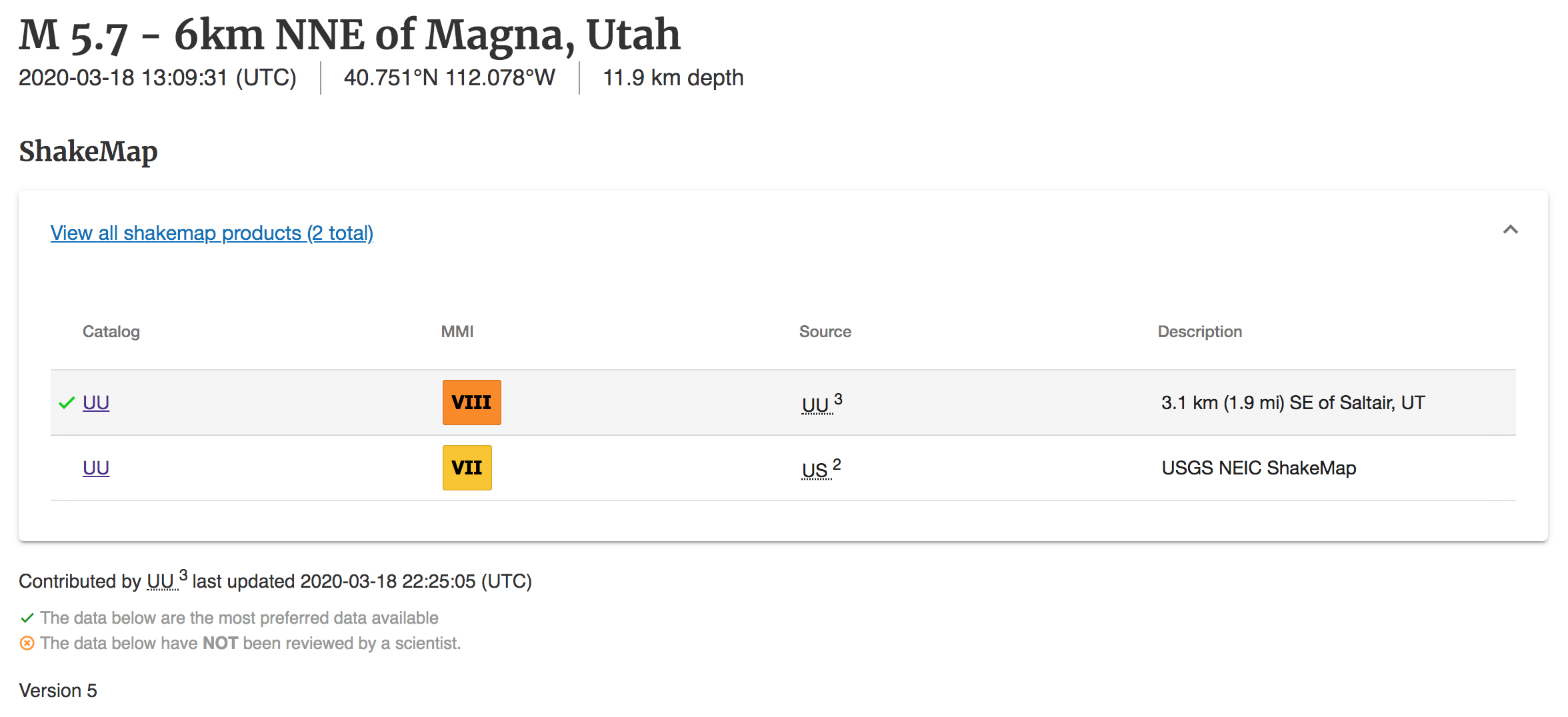
Figure 1: Portion of a ShakeMap webpage showing the Utah (uu) and NEIC/GSM (us) versions of the event.
3.2.2.2. ShakeMap Versions
In addition to multiple possible sources of ShakeMaps for a given event, each source will likely update the ShakeMaps in the immediate minutes and hours after an earthquake. For global earthquakes, GSM (“US”) will be the only ShakeMap source, yet there may be several updates (new versions) of the GSM ShakeMap. By default, GSM will generate Version 1 at the time of triggering from a US origin solution, that is when the event hypocenter and magnitude are released by NEIC. Without other modifications, GSM will then rerun two hours after the origin time. However, GSM will also rerun conditionally, if the event origin is revised, or if new seismic data arrive.
RSN retriggering is often more complex, and numerous reruns and resulting Version updates will be produced. For example, as seen in the lower left of Figure 1, the authoritative ShakeMap from Utah (UU) is on version 5.
Whereas all ShakeMaps from different sources can be access from this web portal, only the more recent version of the ShakeMap products are available. To access earlier versions of any ShakeMap products on can use the getproduct function of the library libcomcat to query the ComCat database (see Accessing ShakeMap Products).
3.2.3. ShakeMap Updating Policy
ShakeMaps are preliminary in nature and will be updated as data arrive from a variety of distributed sources. Our strategy is to update ShakeMaps as warranted from a scientific perspective. We reserve the option to update ShakeMaps as needed to add data or to improve scientific merit and/or presentation of the maps in any way beneficial. This most typical update is after new data arrive, finite-fault models get established or revised, magnitude gets revised, or as improved site amplification maps, ground motion prediction equations, or even interpolation or other procedures become available.
There is no formal “final” version of any ShakeMap. All versions of all products are permanently archived in the USGS ComCat database. ShakeMap version numbers and timestamps are provided on the maps, webpages, grid files, and metadata.
Our practice is to improve the maps as soon as possible, but there are factors beyond our control that can result in delayed updates. For regions around the world, where there are insufficient near–real-time strong-motion seismic stations to generate an adequate strong-ground-motion data-controlled ShakeMap, we can still provide a very useful estimate of the shaking distribution using the ShakeMap software. Site amplification is approximated from a relationship developed between topographic gradient and shear-wave velocity. Additional constraints for these predictive maps come primarily from additional earthquake source information, particularly fault rupture dimensions, observed macroseismic intensities (including via the USGS “Did You Feel It?” system), and observed strong ground motions, when and where available.
For perspective, consider ShakeMap update examples for some significant earthquakes:
For the very deadly 2008 Wenchuan, China, earthquake, the Chinese strong-motion data were not made available for several months.
For the 2011 Tohoku, Japan earthquake, the magnitude was updated from 7.9 to 8.9 over the course of the first hour after origin time. The Japanese strong-motion data processing center was impacted by the earthquake, yet they provided data for nearly a thousand seismic stations within several days after the earthquake. These vital data were added to the ShakeMap as soon as they became available.
Due to telemetry limitations, some important seismic station data for the 2014 American Canyon, California, earthquake came in minutes, hours, and as late as four days after the event. The data were added to the ShakeMap soon after they were received and processed. The magnitude also changed from an initial M5.7 to M6.0, and this, too, affected the ShakeMap. Lastly, the causative fault location was added by the Northern California ShakeMap operators several days after the earthquake.
Updates to Online Maps
Real-time ShakeMap Updates. Changes can be tracked with the ShakeMap version numbers and timestamps found in the metadata, the info.json and grid.xml files, and on the maps themselves (time generated). The info.json file contains timestamps, number of stations used, GMPE information, and many other attributes that could have changed from version to version. Often a text statement is provided that notes significant changes for a particular version.
ShakeMap Atlas Updates. The ShakeMap Atlas uses version numbers for each Atlas event; the overall Atlas collection is also Versioned. Currently ShakeMap Atlas Version 4.0 is online in the ComCat database, and the older Atlas (Version 2.0) can be found via database query tools (getproduct and the libcomcat library).
Scenario Revisions. ShakeMap Scenario collections uses version numbers for each event; the overall scenario collection is named according to their source. Some older scenarios are online on the legacy ShakeMap Archives pages. Scenario ShakeMaps will be revised when the underlying probabilistic seismic map fault segmentation or other particulars (like GMPE selection) change. Older versions will be archived in ComCat (see Accessing ShakeMap Products).
