Welcome to FCPGtools Documentation!
Flow-Conditioned Parameter Grid Tools (FCPGtools) is a Python 3 library
that enables users to quickly create flow-conditioned parameter grids (FCPGs),
as well other gridded output datasets, for use in statistical,
machine learning, and physical hydrologic modeling. FCPGtools can be used in
a Linux-based high performance computing (HPC) environment or locally on your
system.
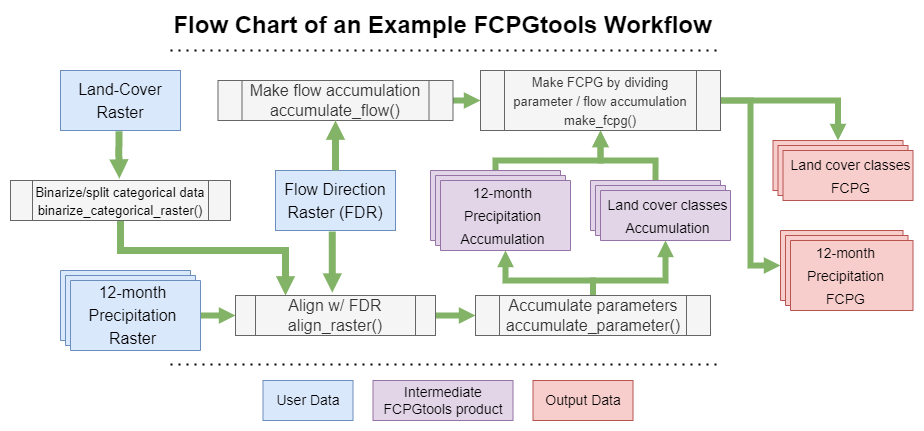
FCPGtools are used to analyze gridded parameter datasets – such as precipitation, slope, or land use – relative to a Flow Direction Grid/Raster (FDG/FDR) derived from terrain analysis, to generate seamless FCPG raster outputs. Each cell in these outputs stores a value that statistically summarizes parameter values for all cells that are upstream, upflow, or uphill.
More specifically, an FCPG is a pre-processing output that stores the upstream average of a parameter datasets for each grid cells in a landscape. These tools allow you to store the upstream maximum and minimum parameter values, or to generate a FCPG with a decay factor that modifies the downstream accumulation calculation of the parameter.
For example, you could use these tools to calculate the average upstream precipitation value for each grid cell in a raster, or the maximum and minimum upstream slope values using a hillslope raster as the input parameter grid.

These types of gridded outputs are useful in a variety of hydrologic modeling applications and can serve as powerful predictive features in machine learning training datasets. This software package has previously been used to generate a seamless dataset of common basin characteristics for the contiguous United States, including mean upstream elevation, slope, minimum and maximum monthly temperature, annual precipitation, land cover class, and latitude.
Use and Citation
The FCPG Tools released to the public domain as they are produced by employees of the U.S. Government in collaboration with private sector partners. If you use these tools in your work, we request that you cite our publication along with a code citation for the release you are using. This helps us ensure that the contributions of the team behind the FCPG Tools are properly recognized, and will help justify the continued maintenance of this library.
Publication
Barnhart, T.B., Schultz, A.R., Siefken, S.A., Thompson, F., Welborn, T., Sando, T.R., Rea, A.H., McCarthy, P.M., 2021, Flow-Conditioned Parameter Grids for the Contiguous United States: A Pilot, Seamless Basin Characteristic Dataset: U.S. Geological Survey data release, https://doi.org/10.5066/P9HUWM6Q.
Code Citation
FCPGtools releases <https://code.usgs.gov/StreamStats/data-preparation/cpg/FCPGtools/-/releases> are commonly assigned authorship in the order of number of contributions. Example citations are provided below.
- Version 2.0.2 was released February, 2023.
Siefken, S.A., X.R. Nogueira, T.B. Barnhart, A.K. Aufenkampe, A.R. Schultz, P. Tomasula. 2023. Flow-Conditioned Parameter Grid Tools Version 2.0.2. https://code.usgs.gov/StreamStats/data-preparation/cpg/FCPGtools/-/releases/v2.0.2.
- Version 1.1.0 was released September, 2022.
Siefken, S.A., T.B. Barnhart, A.R. Schultz, A.K. Aufenkampe, X.R. Nogueira. 2023. Flow-Conditioned Parameter Grid Tools Version 1.1.1. https://code.usgs.gov/StreamStats/data-preparation/cpg/FCPGtools/-/releases/v1.1.1.
- Version 1.0 (IP-112996) was approved on September 3, 2020.
Siefken, S.A., T.B. Barnhart. 2020, Flow-Conditioned Parameter Grid Tools version 1.0. https://doi.org/10.5066/P9W8UZ47
If you encounter and issues with this software, please bring it to our attention by filling out a GitLab Issues Form.
Contents
- Getting Started
- Cookbook and Examples
- Migrating to
FCPGtoolsVersion 2.0 - Function API Reference
accumulate_flow()accumulate_parameter()adjust_parameter_raster()align_raster()binarize_categorical_raster()binarize_nodata()check_function_kwargs()clip()convert_fdr_formats()d8_to_dinfinity()decay_accumulation()distance_to_stream()extreme_upslope_values()find_basin_pour_points()find_fac_pour_point()get_pour_point_values()load_raster()load_shapefile()make_decay_raster()make_fac_weights()make_fcpg()mask_streams()reproject_raster()reproject_shapefile()resample()save_raster()save_shapefile()spatial_mask()value_mask()
- Custom Types and Formats
- Terrain Engine Reference
- Contributing Guide
- Publications and Projects
- References