- java.lang.Object
-
- gov.usgs.earthquake.nshmp.geo.Region
-
- gov.usgs.earthquake.nshmp.geo.GriddedRegion
-
public class GriddedRegion
extends Region
implements Iterable<Location>
 A
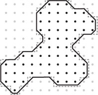
A GriddedRegionis aRegionthat has been discretized in latitude and longitude. Each node in a gridded region represents a small area that is some number of degrees in width and height and is identified by a uniqueLocationat the geographic (lat-lon) center of the node. In the adjacent figure, the heavy black line marks the border of theRegion. The light gray dots mark theLocations of nodes outside the region, and black dots those inside the region. The dashed grey line marks the border, inside which, aLocationwill be associated with a grid node. SeeindexForLocation(Location)for more details on rules governing whether a grid node is inside a region and whether aLocationwill be associated with a grid node.The
Locations of the grid nodes are indexed internally in order of increasing longitude then latitude starting with the node at the lowest latitude and longitude in the region.GriddedRegions are iterable as a shorthand forgetNodeList().iterator().Internally,
GriddedRegions use an anchorLocationto ensure grid nodes fall on specific lat-lon values. This location can be anywhere in- or outside the region to be gridded. If the region contains the anchor location, the anchor will coincide with a grid node. For example, given a grid spacing of 1° and an anchorLocationof 22.1°N -134.7°W, grid nodes within any region will fall at whole valued latitudes + 0.1° and longitudes - 0.7°.Note: Due to rounding errors and the use of an
Areainternally to define aRegion's border,Region.contains(Location)may not always return the expected result near a border. SeeRegion.contains(Location)for further details. For aGriddedRegion, this results in values returned by callsminGridLat()etc. for which there may not be any grid nodes. To guarantee node coverage for aGriddedRegion, say for eventual map output, 'best-practice' dictates expanding a region slightly.Use the
Regionsfactory class to create new gridded regions.
-
-
Field Summary
Fields Modifier and Type Field and Description static LocationANCHOR_0_0Convenience reference for an anchor at (0°, 0°).
-
Method Summary
All Methods Instance Methods Concrete Methods Modifier and Type Method and Description voidaddInterior(Region region)Overridden to throw anUnsupportedOperationExceptionwhen called.AreaareaForIndex(int index)Returns theRegionthat bounds a nodebooleanequals(Object obj)booleanequalsRegion(GriddedRegion gr)Compares thisGriddedRegionto another and returnstrueif they are the same with respect to aerial extent (both exterior and interior borders), grid node spacing, and location.inthashCode()intindexForLocation(Location loc)Returns the index of the grid node associated with a givenLocationor -1 if the associated grid node is ouside this gridded region.List<Integer>indicesForBounds(Rectangle2D rect)Returns the list of grid indices spanned by the bounds of the supplied region.booleanisEmpty()Returns whether this region contains any grid nodes.Iterator<Location>iterator()doublelatSpacing()Returns the longitudinal grid node spacing for this region.LocationlocationForIndex(int index)Returns theLocationat a given grid index.doublelonSpacing()Returns the latitudinal grid node spacing for this region.doublemaxGridLat()Returns the maximum grid latitude.doublemaxGridLon()Returns the maximum grid longitude.doubleminGridLat()Returns the minimum grid latitude.doubleminGridLon()Returns the minimum grid longitude.intmove(int index, gov.usgs.earthquake.nshmp.geo.Direction dir)Returns the index of the node at the suppliedDirectionfrom the node at the supplied index.LocationListnodes()Returns the locations of all the nodes in the region as aLocationList.intsize()Returns the total number of grid nodes in this region.-
Methods inherited from class gov.usgs.earthquake.nshmp.geo.Region
area, border, bounds, contains, contains, distanceToLocation, equalsRegion, extent, interiors, isRectangular, name, toString
-
Methods inherited from class java.lang.Object
clone, finalize, getClass, notify, notifyAll, wait, wait, wait
-
Methods inherited from interface java.lang.Iterable
forEach, spliterator
-
-
-
-
Field Detail
-
ANCHOR_0_0
public static final Location ANCHOR_0_0
Convenience reference for an anchor at (0°, 0°).
-
-
Method Detail
-
latSpacing
public double latSpacing()
Returns the longitudinal grid node spacing for this region.- Returns:
- the longitudinal grid node spacing (in degrees)
-
lonSpacing
public double lonSpacing()
Returns the latitudinal grid node spacing for this region.- Returns:
- the latitudinal grid node spacing (in degrees)
-
size
public int size()
Returns the total number of grid nodes in this region.- Returns:
- the number of grid nodes
-
isEmpty
public boolean isEmpty()
Returns whether this region contains any grid nodes. If a regions dimensions are smaller than the grid spacing, it may be empty.- Returns:
trueif region has no grid nodes;falseotherwise
-
move
public int move(int index,
                gov.usgs.earthquake.nshmp.geo.Direction dir)
Returns the index of the node at the suppliedDirectionfrom the node at the supplied index.- Parameters:
index- to move fromdir- to move- Returns:
- index at
Directionor -1 if no node exists - Throws:
NullPointerException- if supplied index is not a valid grid index
-
equalsRegion
public boolean equalsRegion(GriddedRegion gr)
Compares thisGriddedRegionto another and returnstrueif they are the same with respect to aerial extent (both exterior and interior borders), grid node spacing, and location. This method ignores the names of theGriddedRegions. UseGriddedRegion.equals(Object)to include name comparison.- Parameters:
gr- theRegionsto compare- Returns:
trueif thisRegionhas the same geometry as the suppliedRegion,falseotherwise- See Also:
equals(Object)
-
addInterior
public void addInterior(Region region)
Overridden to throw anUnsupportedOperationExceptionwhen called. The border of aGriddedRegionmay only be set on initialization. To create aGriddedRegionthat has interiors (donut-holes), first create aRegionwith the required border and interiors usingRegion.addInterior(Region)and then use it to initialize aGriddedRegion.- Overrides:
addInteriorin classRegion- Parameters:
region- to use as an interior or negative space- Throws:
UnsupportedOperationException- See Also:
Region.addInterior(Region)
-
nodes
public LocationList nodes()
Returns the locations of all the nodes in the region as aLocationList.- Returns:
- a list of all the node locations in the region.
-
locationForIndex
public Location locationForIndex(int index)
Returns theLocationat a given grid index. This method is intended for random access of nodes in this gridded region; to cycle over all nodes, iterate over the region.- Parameters:
index- of location to retrieve- Returns:
- the
Locationornullif index is out of range
-
indicesForBounds
public List<Integer> indicesForBounds(Rectangle2D rect)
Returns the list of grid indices spanned by the bounds of the supplied region. Bounds refers to the rectangle that completely encloses a region. Note that this is a list of all nodes for which any part, however small, overlaps the supplied rectangle and is not restricted to grid centers.- Parameters:
rect- to process- Returns:
- the list of grid indices that intersect the bounding box of the supplied region
- Throws:
IllegalArgumentException- if the supplied rectangle is not completely enclosed by theiRegion
-
areaForIndex
public Area areaForIndex(int index)
Returns theRegionthat bounds a node- Parameters:
index- of the node of interest- Returns:
- the bounding region of the specified node
-
indexForLocation
public int indexForLocation(Location loc)
Returns the index of the grid node associated with a givenLocationor -1 if the associated grid node is ouside this gridded region. For aLocationto be associated with a node, it must fall within the square region on which the node is centered. Note that this allows for someLocations that are outside the region border to still be associated with a node. Conversely, aRegion.contains(Location)may returntruewhile this method returns -1. Users interested in node association should always use this method alone and test for -1 return value.Region.contains(Location)should NOT be used a as a test prior to calling this method.
The figure and table below indicate the results produced by callingcontains()orindexForLocation(). The arrows in the figure point towards the interior of theRegion. The dots mark the centeredLocationof each grid node and the numbers indicate the index value of each. Remember that both methods test for insidedness according to the rules defined in theShapeinterface.
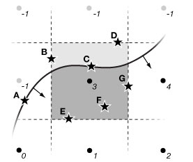
Location contains(Location)indexForLocation(Location)A true-1 B false3 C false3 D false-1 E true3 F true3 G true4 - Parameters:
loc- theLocationto match to a grid node index- Returns:
- the index of the associated node or -1 if no such node exists
-
minGridLat
public double minGridLat()
Returns the minimum grid latitude. Note that there may not actually be any nodes at this latitude. See class note. If the region is devoid of nodes, method will returnDouble.NaN.- Returns:
- the minimum grid latitude
- See Also:
Region.contains(Location)
-
maxGridLat
public double maxGridLat()
Returns the maximum grid latitude. Note that there may not actually be any nodes at this latitude. See class note. If the region is devoid of nodes, method will returnDouble.NaN.- Returns:
- the maximum grid latitude
- See Also:
Region.contains(Location)
-
minGridLon
public double minGridLon()
Returns the minimum grid longitude. Note that there may not actually be any nodes at this longitude. See class note. If the region is devoid of nodes, method will returnDouble.NaN.- Returns:
- the minimum grid longitude
- See Also:
Region.contains(Location)
-
maxGridLon
public double maxGridLon()
Returns the maximum grid longitude. Note that there may not actually be any nodes at this longitude. See class note. If the region is devoid of nodes, method will returnDouble.NaN.- Returns:
- the maximum grid longitude
- See Also:
Region.contains(Location)
-
-